The maps of Mānoa played a very important role in the proposal-making process. The map that really influenced this proposal was the 1882 survey map of Mānoa that includes the names of the ʻili ʻāina in Mānoa valley. Traditional Hawaiian division of land was dependent on how to make the best use of resources and how to utilize those resources in a sustainable way so that they would last for generations to come. The mokupuni or island was first divided into different moku or large divisions of land. Within the large moku there are many ahupuaʻa, which are long land divisions that begin at the top of the mountain and go down to the ocean. The ahupuaʻa boundaries were determined by the aliʻi or chief dependent on the resources available within that area. Within the ahupuaʻa land divisions there were smaller land divisions called ʻili ʻāina that all had their own name and purpose for being named. This is why the 1882 map of Mānoa is so significant to educate people on traditional Hawaiian divisions of land and naming of land divisions.
2 Maps, 1 Mission
In order to see exactly which ʻili ʻāina lie beneath the UH Mānoa campus, we first had to consider how we would be able to put the 1882 map of Mānoa on top of the current UHM campus map. Below are the two maps:
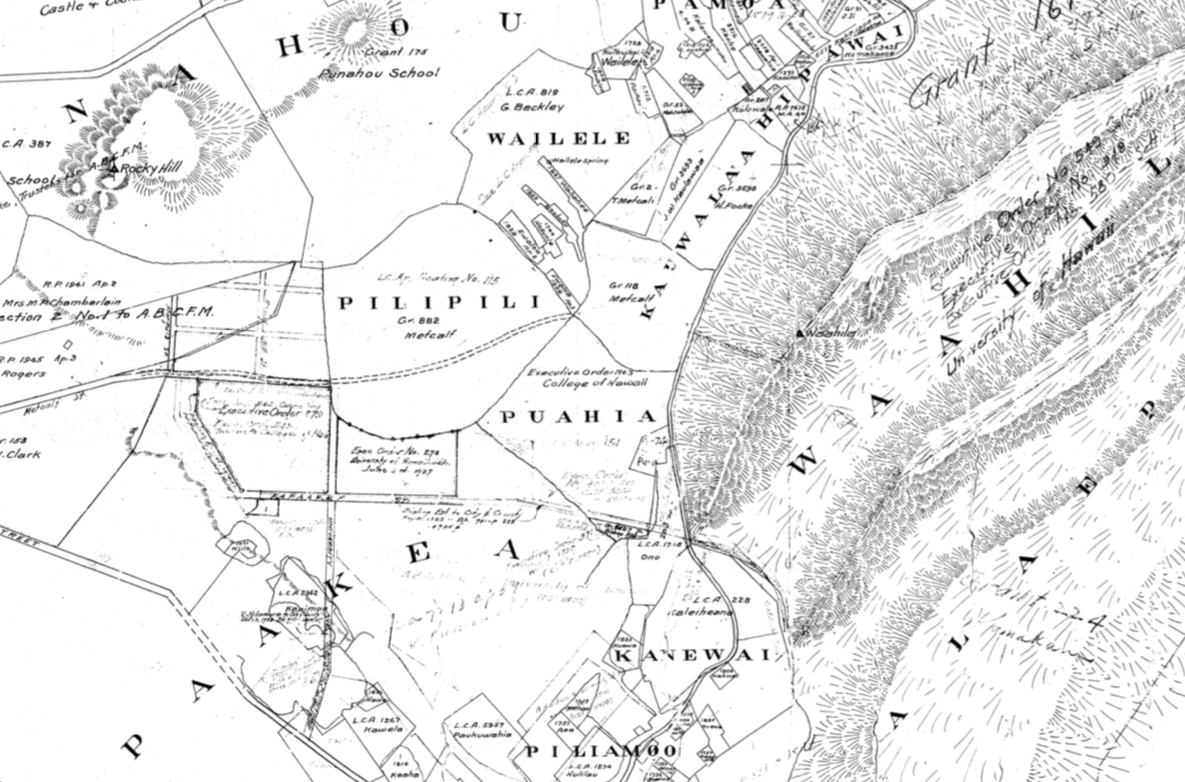
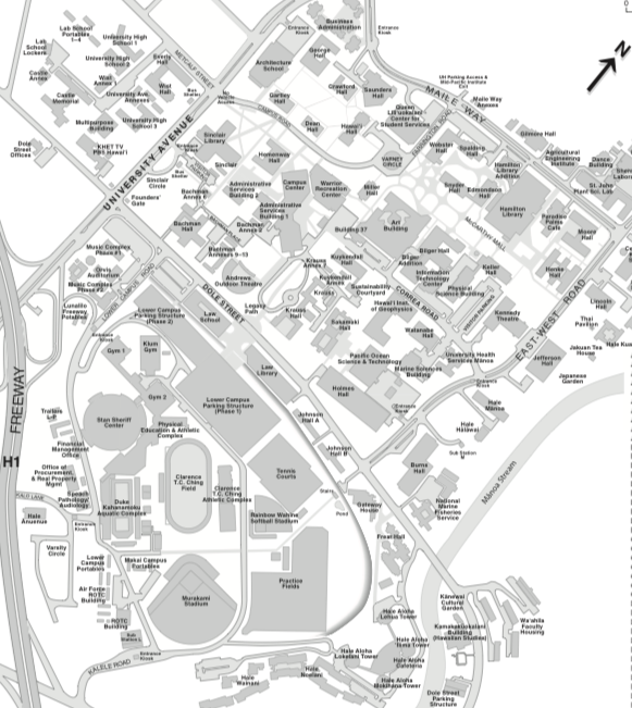
Luckily the 1882 map included University Avenue as well as Kapaʻakea Street. Today, we still have University Avenue in the UH Campus Map, but Kapaʻakea Street was renamed to Dole Street. These two streets made it possible to line the two maps up on top of each other. Another helpful feature on both of these maps is the inclusion of the Mānoa Stream on the right side. This helped us to scale the image accordingly by using the stream as a reference.
The Overlay Map
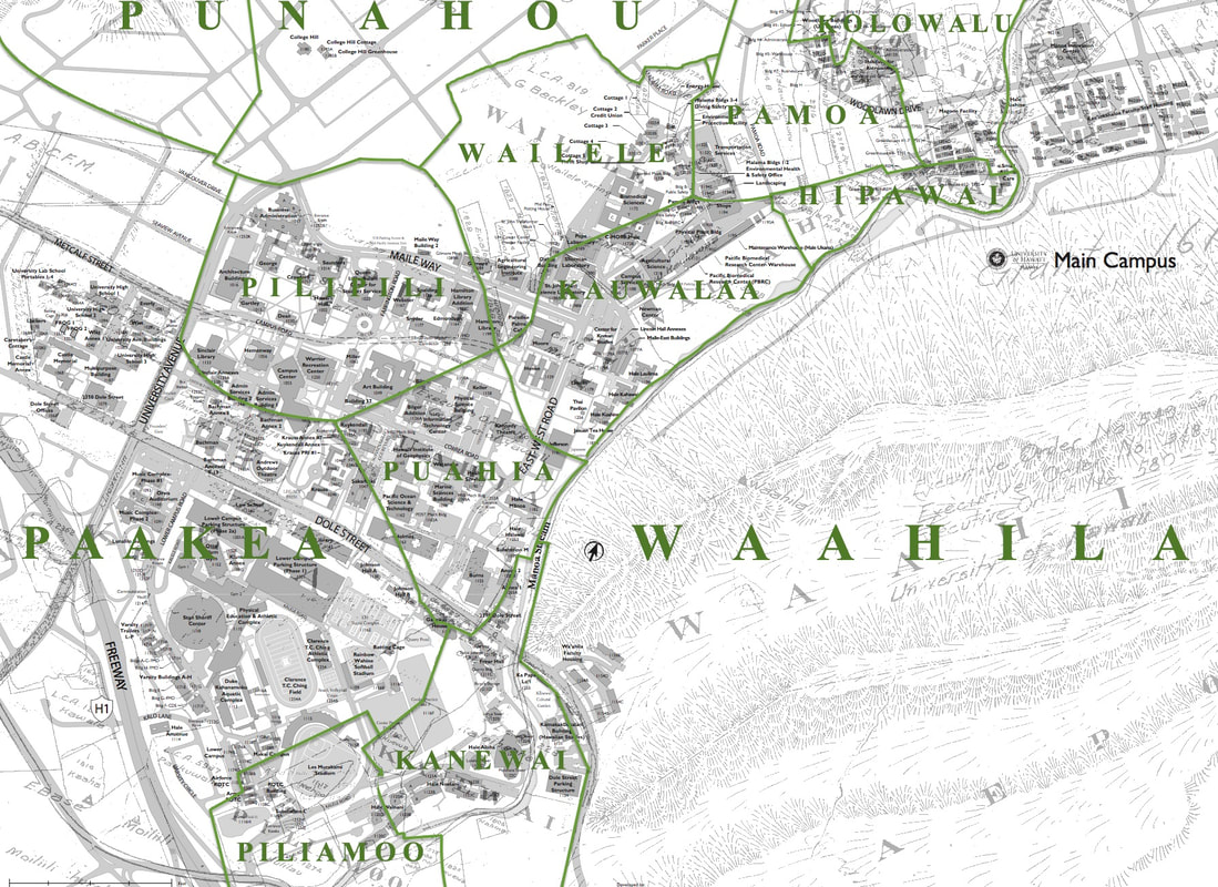
The overlay map of Mānoa opened our eyes to many possibilities for educational signage on campus as well as web resources and clickable features as a future avenue for this first draft. The groundbreaking thing about this map is that it allowed us to see which campus buildings are located within a certain ʻili ʻāina, which then allows the possibility of geo-referencing location not only according to buildings on campus but also according to traditional Hawaiian ʻili ʻāina as well.
Proposals
The proposals we came up with in regards to the overlay map of Mānoa are mostly physical signs on campus in places where there is a lot of student foot traffic. These signs are meant to be an educational opportunity and we plan to make the signs bilingual with Hawaiian as the primary language on the signs. On top of the signs we also would have a brief explanation of traditional Hawaiian land divisions so students would have an idea of what they are looking at and why it is significant. Also, to keep up with technology we propose that the signs include QR codes that link to a website where the map is interactive and explained in detail.
Large Multilayered Campus Map
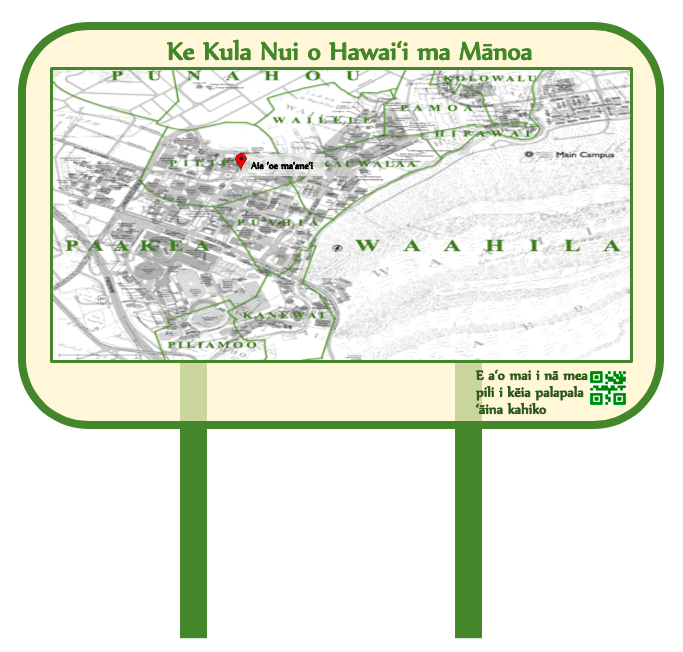

Large Campus Map Displayed in Hawaiian Large Campus Map Displayed in English
ʻIli ʻĀina Building Signage
A key signage project that we are proposing is the signing of each building along with the ʻili ʻāina name that the building is located in. These would
be smaller sized signs that are located outside of every main building on campus that first tells the building name and then tells what ʻili ʻāina the
building is within. Below are examples of ʻili ʻāina building signs in Hawaiian and in English but we also would like to imagine the possibility of having
bilingual signage as well.

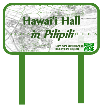
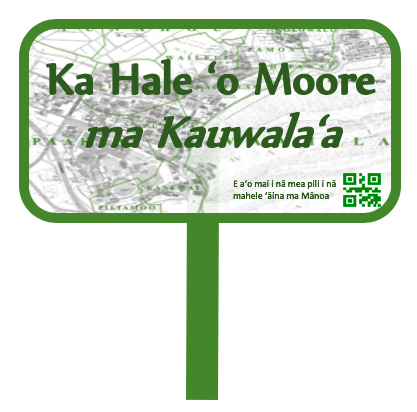
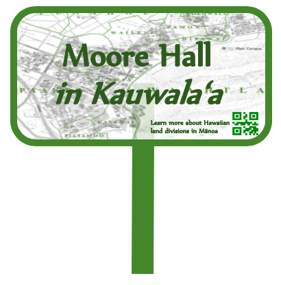
The above examples show ʻili ʻāina sign designs for two different campus buildings that have the multilayered map of Mānoa as the background. These signs could be made in Hawaiian, English, and bilingual versions for every main building on campus so students will begin to learn traditional Hawaiian ʻili ʻāina names simply by walking to and from their classes.
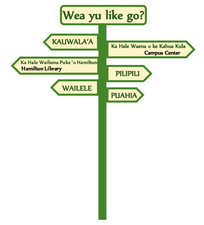
Multi-Directional Sign Posts
|
We also propose multi-directional sign posts that will serve as way finding signage on campus. For these sign posts we propose that Pidgin or Hawaiʻi Creole be featured with a fun phrase such as "wea yu like go?" Each one of the directional arrows will be bilingual Hawaiian and English or they could be multilingual and include other languages as well. In our research, unsurprisingly, we discovered that Pidgin was not tolerated at the university and these stigmas of Pidgin still linger in Hawaiʻi today; especially in educational institutions, which is why we propose it be featured in sign designs.
ʻIli ʻĀina featured in this multi-directional post: - Kauwalaʻa - Pilipili - Wailele - Puahia Campus Buildings Featured in this sign - Campus Center - Hamilton Library We propose that there be multiple multi-directional signs on campus (such as the example on the left) that highlight ʻili ʻāina and key campus buildings. |
